Better Streets MKE, Vol. 16

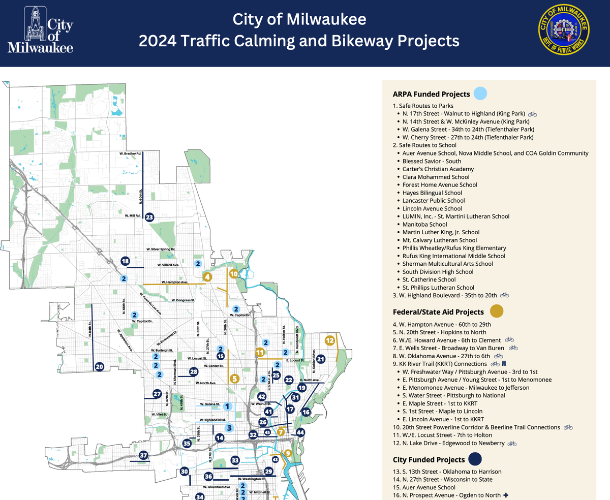
Apologies for a bit of a delay between newsletters. We highly encourage you to spend some time reviewing the 2024 Traffic Calming and Bikeway Projects map released by DPW.
You can see the full map here, thanks to the Milwaukee Journal Sentinel, which also wrote about the projects.
Some projects we're particularly excited about:
- Safe Routes to School & Parks: Lots of investment around many schools & parks
- Van Buren's rapid rebuild to included a protected 2-way cycle track
- Oklahoma's (6th to 27th) rapid rebuild on the southside, although unfortunately that project will have a mix of more and less protected bike infrastructure
- KKRT Connections, which should substantially improve access and safety around the KK River Trail and some painful intersections near the Third Ward
- The 20th Street Powerline trail, just north of Capitol Drive, which will also include improvements to accessing the Beerline Trail. It's great to see new trails!
- Improvements to North Avenue, which had planters added to create a protected bike lane last year. These planters have taken quite a beating over the past year, and drivers frequently illegally park along the corridor. We're thankful for the investment by the East Side BID for the temporary street design, but definitely looking forward to new investments.
- Connecting the Walnut Street/Pleasant Street project to downtown by building a protected bike lane from Vel Phillips to Water Street. This brings a safe connection from near north side neighborhoods to downtown, the river, lake, and beaches.
- Investments in W Scott and W Washington Streets to make them bike boulevards (finally!!).
Oops, that was a lot. Well, it turns out, there's a lot to be excited about.
Upcoming Events
Milwaukee County Committee on Parks and Culture
This meeting will include an update on the Jackson Park Drive project as well as consideration of a resolution from Supervisor Burgelis to direct the parks to reduce the scope of their planned road-to-trail conversion (File #24-350). Better Streets MKE supports Alternative B, the full road-to-trail conversion, and encourages folks to show up and speak up in support– see below under projects for more details.
You can request to speak by filling out a form here, scroll down to the Parks and Culture committee.
Tuesday, March 12th, 2024
9:00 AM
Hybrid
Milwaukee County Courthouse, Room 203-R
Virtual Meeting link
Transit: 12, BLU
3 blocks or less from CN1, 30, 31, 34, 80, 81
Bublr station ~2 blocks away at Wells & James Lovell
Pedestrian and Bicycle Advisory Committee
Meetings are open to the public and held on the third Friday of the month. You can sign up for updates on meetings and agendas via e-Notify.
Friday, March 15th, 2024
8:30 to 10:00am
Hybrid
Zeidler Municipal Building, 5th floor
Virtual Meeting link
Transit: 15, 18, 57, GRE
3 blocks or less from the 14, 19, 30, 33, and CN1.
Bublr station on Van Buren St. near Wells St.
Michigan Street Redesign Public Input Meeting
The City of Milwaukee is redesigning W. Michigan Street from N. Water Street to N. 8th Street to improve safety, comfort, and accessibility for everyone using the street, including drivers, cyclists, and pedestrians.
Thursday, March 21st, 2024
11 am to 1 pm
3rd Street Market Hall, Starlight Room
275 W Wisconsin Avenue
Transit: 30, CN1, 57, 12
3 blocks or less from the 15, 18, 19, 34, 80, 81, BLUE, GREEN, Hop.
Bublr station at 3rd Street Market Hall.
Critical Mass
A (fun!) monthly no-drop bike ride, with a fabulous website. Rolling out 6:00 pm sharp and ending at Boone and Crockett this month.
Friday, March 29th, 2024
Rolling out 6:00 pm sharp
Red Arrow Park
920 N Water St
Transit: GREEN, 15, Hop, 57, 18, 33, 19, 30, CN1, 14
Bublr station at Red Arrow Park
Eyes on Projects
Psst - we don’t cover every project in every volume of this newsletter if there is no major new information. Check out previous newsletters for more updates about projects.
Lapham Boulevard
Lapham Boulevard (between 6th and 16th Streets) was given a rapidly-implemented road change in 2023, with a paint-and-post design that created a parking-protected bike lane, a closed slip lane on the west side of the project, and a road diet. This was an ARPA-funded project, which had a quick timeline and minimal public input. At a meeting in February, the city admitted that it could have done a much better job communicating with residents but that despite some complaints, the redesign would stay (and will be receiving investments to improve the design). Several residents spoke in favor of the design as well.
Vision Zero
Vision Zero is a policy to reach zero traffic deaths and life-changing injuries by 2037, through a mix of strategies including redesigned streets. Take this 10-minute survey to help shape the City of Milwaukee Vision Zero Action Plan.
Branching returns to route 30
MCTS has backtracked slightly on the MCTS NEXT project's approach to bus route design. Due to complaints from some neighbors on the East side, route 30 will now branch on the eastern end of its route, with some buses serving Downer Ave and some serving Maryland Ave. But this isn't without downsides: buses will come to both branches less often than a consistent 30 line would have, and UW-M students (who are a substantial rider base on this end of the line) likely had little ability to provide input. This is a good example of the power of handful of louder, organized voices to make change. While those changes may or may not be worthwhile, making changes based on limited feedback versus data and consistent policy is concerning.
MCTS releases its CONNECT 2 plans
MCTS also released its plans for the CONNECT 2 (Bus Rapid Transit) line, which would primarily run along 27th Street, starting at Bayshore and ending at IKEA. The line would be very similar to today's PURPLE line, with benefits that come with BRT including (some) dedicated lanes, in-lane boarding, traffic signal priority, all-doors boarding, and superior stations. All of that is designed to make the ride more comfortable and faster.
Unfortunately, the County has offered some plans that are disappointing for a full BRT experience. Near the end of these materials from the project website, bus-only lanes may not be provided along a part of South 27th Street. Bus-only lanes are a major component of successful BRT projects, as part of the goal of BRT is to be as close to rail as possible. Rail is grade-separated and thus has its own dedicated lanes away from traffic. Herein lies the challenge: improvements to transit like BRT should not just be about benefitting current transit users. They should be about converting some drivers into transit users, for at least some of their trips. That means making the bus very fast, safe, and convenient, and yes, that also means it may making driving and parking less convenient. Not having dedicated lanes (as we have done in Westown for the CONNECT 1) leads to slower buses mixed with traffic. A bus filled with 30 or so riders should be prioritized over a handful of single-occupant vehicles. That is the fair and equitable way – and drivers will still have unchanged access and connectivity if they choose to drive.
The County is also proposing vertical separation for bus-only lanes, which would also be a significant traffic calming improvement and likely save lives along 27th Street, which is one of the most dangerous streets in the County.
You can still take a survey about this project here.
Jackson Park Drive
Despite last year's shared revenue deal, many County and City departments are still having a tough time emerging from decades of austerity and budget cuts. The Milwaukee County Parks, which have seen flat funding levels for 30 years now, have a capital backlog estimated at about ~$500 million. Of that sum, about half are road projects. Many of the roads the county is responsible for are wide and overbuilt, and also deteriorating. For example, Jackson Park Drive was last rebuilt in 1984 with an expected lifespan of 20 years. It is now in very poor condition.
Part of the County's strategy in addressing the capital backlog is to reduce the amount of roadways it is responsible for. This supports many of the County's goals, not only freeing funds to address other priorities, but also reducing the impact of road salt and stormwater runoff on our rivers and lakes, and connecting neighborhoods with places to ride, walk, and roll that are safe and comfortable for all ages and abilities.
In the case of Jackson Park Drive, the county has proposed converting a section of roadway to a multi-use trail. This project has been controversial (see Urban Milwaukee for excellent coverage), and opponents are well-organized. Please consider attending (in-person or virtually) the parks committee meeting on 3/12 to voice support for Alternative B, the partial trail conversion proposed by Parks staff.
Curious about a project? Check out Engage MKE
There are many road projects happening in Milwaukee. To learn more about them, check out Engage MKE. This resource is a good place to start for understanding the major projects occurring in Milwaukee. Projects include: